The Van Brienenoord bridge
Introduction - How to get on it - Nighttime view - Climbing story - Daytime view legal
Introduction - In the sixties, to relieve the Maas Tunnel route through the city, the Rotterdam ring road was constructed. The Van Brienenoord Bridge (1965) formed the eastern river crossing. The bridge grew into the largest traffic roundabout in the region and the most infamous bottleneck in the Netherlands. It was therefore decided in 1984 to erect a second bridge to the west of the first. ln 1989 the second Van Brienenoord Bridge was floated in over the river. The number of lanes was doubled to twelve.
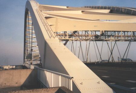
The bridge consists of a steel main span, a bascule bridge with a navigable width af 51 m and at the north and south sides a shore bridge of nine spans af 50.75 m in prestressed concrete. The total length is approximately 1300 m. To hinder shipping as little as possible a main span of 287 m proved essential. The arch is connected by diagonal steel tension cables to steel main girders 3.90 m in height that carry the road deck.
The forbidden side - On the East side there are two lanes for pedestrians and cyclists. This is the official route for non-motorized traffic.
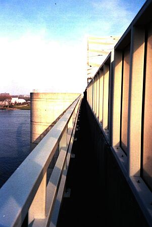
| February (?) 2002 On the West side there is no lane - only a 75 cm strip of asphalt between the railing of the bridge and the sound-screen that lines the highway. It is accessible by walking the emergency strip of the highway and then slipping behind the sound-barrier. Then you have a long walk up the bridge. During all this time you're as visible as hell to all the traffic on the large highway crossing under you. But on a Sunday, at 9:00 AM no one seemed to care. Anyway - we expected to get away with a reprimand if caught. |
 |
 |
A lot of wild plants - and even a small tree grow in the mud that has collected in this small strip. There is not much graffiti - which is surprising seeing how accessible the place is. At the top there is a nice round platform with a terrific view of the city and the river.
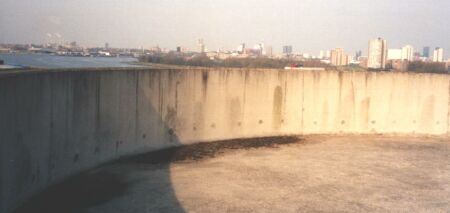
The platform - What a picnic place
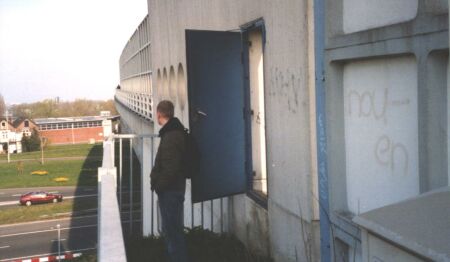
| We discovered a - rather dangerous - way to get into the understructure of the bridge. You have to make a step over a potential 20m drop. But it looks very promising and we have to research it further. And if you walk further along the side of the bridge then you could climb onto the painter's gondola that runs under the whole width of the bridge. I will have to take Ben or Tomas with me - usually I'm not so bold. | 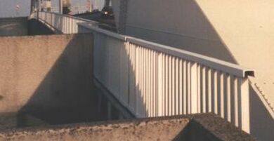 |
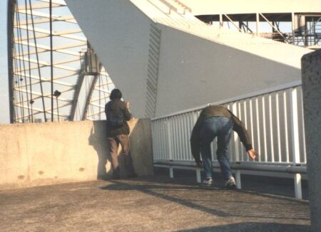
In theory the bridge-operators could see you from their watchtower - And the car's could see you too
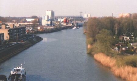
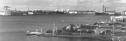
The island of Brienenoord - In the background Feyenoord soccer stadium - The Euro championships were played here in 2000
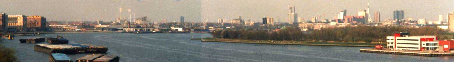
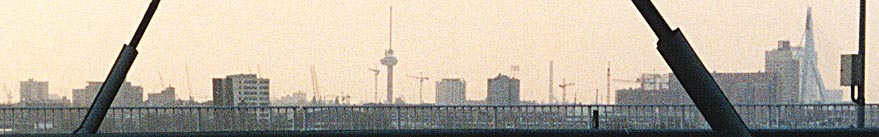
Panoramic view from South Rotterdam to City Center -> scroll to see it all ...
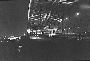
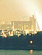
Nighttime view - From this "wrong" side of the bridge you get a great view of the river, of the "Island of Brienenoord" and the skyline. At night it's especially impressive. That's how I discovered it, sometimes in the autumn of 2000.
After a walk of 500 m you reach the arch. It would be a great place for a picnic. Walking further than this point is dangerous because the bridge-operator can see you from his watchtower and he (most likely) will alert the police.
I took this walk at night and I thought I was completely invisible because of the darkness. When I got down again I saw that the sound-screen is translucent and that my silhouette must have been visible for miles around. But people simply don't look up - and when they do, they don't seem to care.
At night this view is amazing
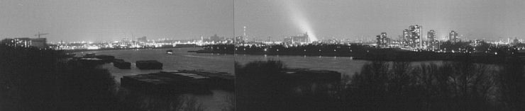
The lightbeam is the Erasmus-bridge that's lit at night - Talking about light pollution - no stars at night here ...
| Euromast | Erasmusbridge | Willemsbrug | Watertower |
 |
 |
 |
 |
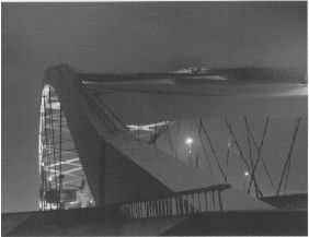
Climbing the arch of the bridge - I haven't done this. You will certainly be caught and prosecuted as the following story demonstrates:
| Last Tuesday two men from Delft, both aged 23, caused some confusion in Rotterdam. They made a bet that they would walk the arch of the Van Brienenoord bridge. The amount was 1 guilder (0,5 euro). The adventurous types exposed themselves to mortal danger by walking the steel structure high above the highway. When they climbed down to floor-level they were awaited by the police. - Source: De Telegraaf-i, 15 april 1997 |
The reality is less adventurous than the story suggests. A convenient walkway runs all along the arch and a solid railing reduces the chance of a fall. If I knew that I could avoid arrest - I would climb the arch without hesitation. Take a look at the opening picture and see for yourself.
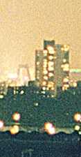
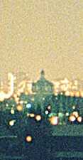
Daytime view from the legal side - The daytime view from the legal side is less impressive. These pictures were taken from the legal (East) side of the bridge. Here the view is cluttered by the cables and railings of the bridge. You cannot see the river in this direction. But still the skyline is impressive.
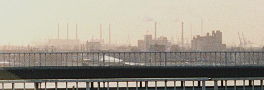
From left to right - The power station at Heijplaat (5 chimneys, now demolished), the waste-incinerator plant (with smoke cloud) and the chimneys of the Shell-refinery in Pernis.
From left to right - The Euromast, the office of Van Ommeren, the 1989 building, Powerstation Marconiplein, the Justice-court and the Erasmusbrug.
17/10/98 - In the afternoon Kaspar had invited his friend Max. When I thought they had played computer games too long, I took them outside. We walked over the Brienenoord bridge and watched the ships go by underneath.
The boys (7 and 8 years) enjoyed looking through the cracks into the depths below (it's 65 meter high) and throwing small pebbles over the side of the bridge. But only in places where they couldn't do any harm.
In the middle of the picture you can see Krimpen aan den IJssel and the four towers of the "Algerabrug".
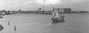
It was spectacular when the bridge had to open to let a Russian ship go through (called "MIR", just like the space station).
Behind the ship you see the inevitable wharf of "Van der Giessen - De Noord". It's on every view in this neighbourhood. It's so large and high that it dominates the landscape.
The west side of the bridge gives you a nice view, but no adventure. It is open for pedestrians and cyclists. The east side is a challenge. There is a narrow path that is not meant to be accessible. But there are no camera's as far as I've seen. You could get on this side by walking 50m along the emergency strip of the southbound highway. It's a project for the future. - Yes, in 1998 it was a project for the future. But now I've been there and it's spectacular. See above ...
Go to: Strange urban places, Home
© 1998 discovery - 2000 first expo - 2002 re-exploration with Ben - P. Kazil